
Датотека:Volga River Delta and Caspian Sea (MODIS 2016-08-29).jpg

Veličina ovog prikaza: 800 × 594 piksela. 6 drugih rezolucija: 320 × 238 piksela | 640 × 475 piksela | 1.024 × 760 piksela | 1.280 × 950 piksela | 2.560 × 1.900 piksela | 4.128 × 3.064 piksela.
Originalna datoteka (4.128 × 3.064 piksela, veličina datoteke: 1,17 MB, MIME tip: image/jpeg)
.jpg)
Opis izmene
| Opis |
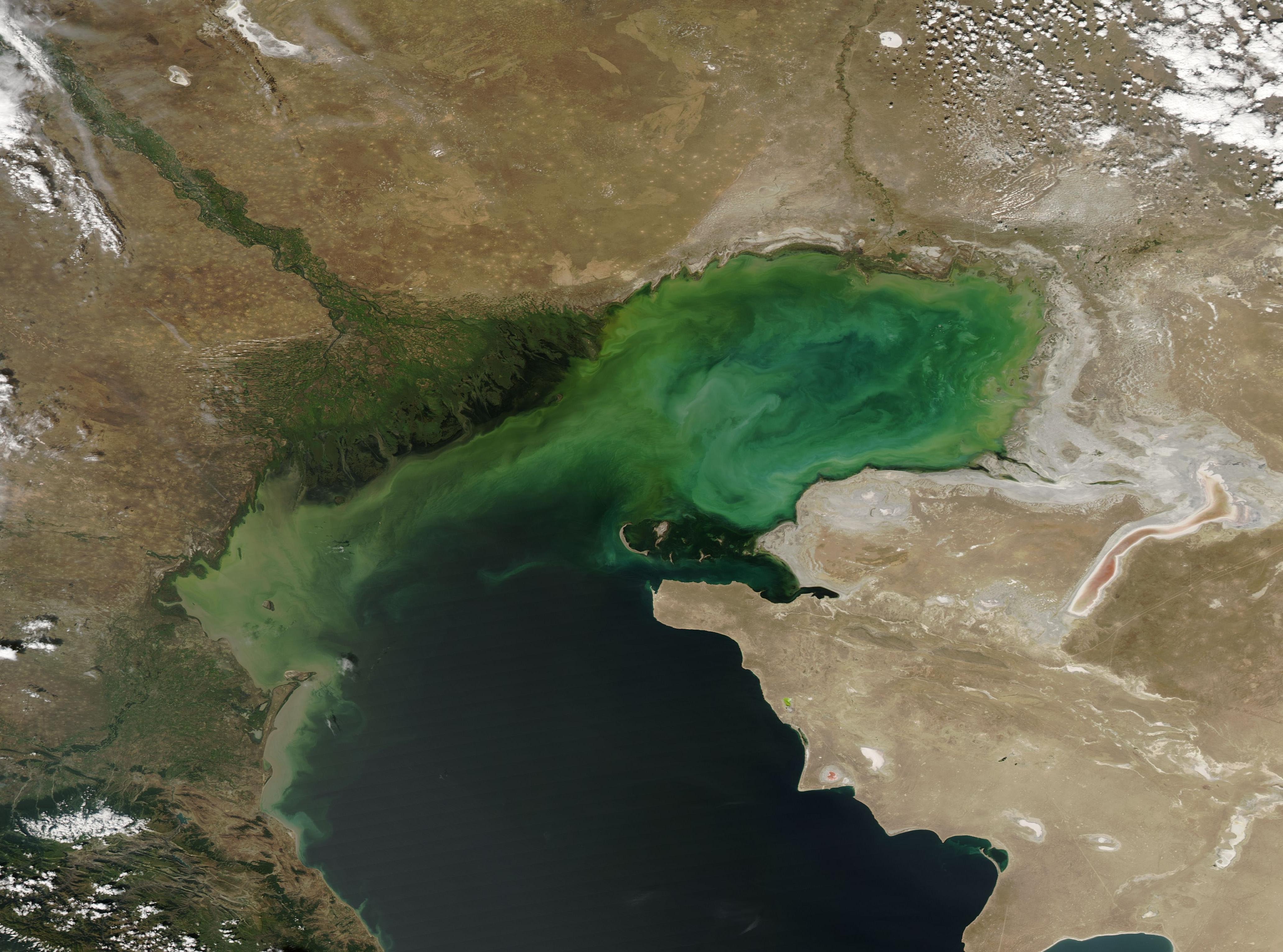
English: The Volga River stretches across much of Russia, rising in the Valday Hills in northwestern Russia and winding about 2,300 miles (3,700 km) before draining into the Caspian Sea. It drains over 1.3 million square kilometers of catchment area, and is the main source of fresh water to the brackish Caspian Sea. The broad Volga Delta is both beautiful and fertile, with high importance as home to about fifty species of fish, as well as a nesting area for approximately 99 species of bird, 27 of which are listed as vulnerable in the Red Book of Russia.
On August 25, 2016, the Moderate Resolution Imaging Spectroradiometer (MODIS) aboard NASA’s Aqua satellite captured a stunning true-color image of the Volga River Delta and the Caspian Sea. The rich greens of the vegetation along the braided Volga River, as well as the reeds, cattails, and other plants within the Delta stand out in bright contrast to the tans of the arid land nearby. Where the runoff from the Volga pours into the Caspian Sea, sediment – and possibly blooms of phytoplankton – color the brackish water with a variety of tans, greens, and aqua. |
||
| Datum | Taken on 25. avgust 2016. | ||
| Izvor |
Volga River Delta and Caspian Sea (direct link)
|
||
| Autor | Jeff Schmaltz, MODIS Land Rapid Response Team, NASA GSFC |
| This media is a product of the Aqua mission Credit and attribution belongs to the mission team, if not already specified in the "author" row |
Licenciranje
| Ова датотека је у јавном власништву зато што је њен аутор НАСА. НАСА-а политика ауторских права наводи „Материјали НАСА-е нису заштићени ауторским правима осим ако није другачије наведено“. (Погледајте Template:PD-USGov, NASA copyright policy page или JPL Image Use Policy.) | ||
 |
Упозорења:
|
Istorija datoteke
Kliknite na datum/vreme da biste videli tadašnju verziju datoteke.
| Datum/vreme | Minijatura | Dimenzije | Korisnik | Komentar | |
|---|---|---|---|---|---|
| trenutna | 21:22, 15. februar 2024. | | 4.128 × 3.064 (1,17 MB) | OptimusPrimeBot | #Spacemedia - Upload of http://modis.gsfc.nasa.gov/gallery/images/image08292016_250m.jpg via Commons:Spacemedia |
Upotreba datoteke
Sledeća stranica koristi ovu datoteku:
.jpg)